OVERVIEW
Capital Tableland(s), also known as Arnland, is a plateau which borders the electorate of Burnett. It hosts the second largest city and the national capital in Ainslie, Arnton and the region averages at 800m above sea level. The region's main distinctive feature is the Burnett River which flows down from Hauton Tops and meets with another river in the Burnett Electorate. The region corresponds to the TWI Weather Office forecast area of the same name.
HISTORY
Arnton and the Capital Tableland were almost constantly occupied since the beginning of Ahnslen History. It housed the headquarters of the Arnish Empire, and was the initial lands of the Karaiki-Novonen people in the ancient times. Arnton has been threatened by many bushfires, but has since been relocated since unification in order to mitigate the threat.
TOWNS AND CITIES
Arnton
Arnton, at an average elevation of 560 metres is comprised of 4.2 million inhabitants and resides within the electorate of Wesland. Established in 1845 at the foothills of higher terrain, it escapes the clutches of urban sprawl which was so common in cities from that era. Arnton is the home of sport in Ainslie, with a major sporting complex on the northern banks of the river overlooking the commercial district in the south.
Arnton, at an average elevation of 560 metres is comprised of 4.2 million inhabitants and resides within the electorate of Wesland. Established in 1845 at the foothills of higher terrain, it escapes the clutches of urban sprawl which was so common in cities from that era. Arnton is the home of sport in Ainslie, with a major sporting complex on the northern banks of the river overlooking the commercial district in the south.
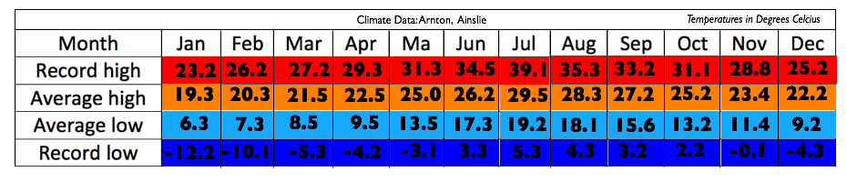
Climate table for Arnton