OVERVIEW
Southern Floodplains, also known as Staffe, is one of the lowest regions in Ainslie. It is in the electorate of Burnett, and is a combination of surf beaches and coastline. It is the most populated region in Burnett, and houses its capital, Wagstaffe. The region borders Manning. The region corresponds to the TWI Weather Office forecast area of the same name
HISTORY
The Southern Floodplains were first populated by the Ipachi people, who escaped the region due to its level of flooding. The city was reinstated when the Arnish empire was founded and continued through history due to a unique form of housing allowing minimal destruction to happen to the area when it floods.
TOWNS AND CITIES
Wagstaffe.
Wagstaffe, at an elevation of 20 metres above sea level is comprised of 230,000 inhabitants. It is the electoral capital of Burnett, and is a agricultural centre, featuring widespanning crop farms just outside of the city, including rice farms. Wagstaffe is known for its near yearly flooding events, where a combination of a lake, river and ocean cause a fatal combination.
Wagstaffe, at an elevation of 20 metres above sea level is comprised of 230,000 inhabitants. It is the electoral capital of Burnett, and is a agricultural centre, featuring widespanning crop farms just outside of the city, including rice farms. Wagstaffe is known for its near yearly flooding events, where a combination of a lake, river and ocean cause a fatal combination.
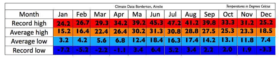
Climate table for Borderton